A Walk Three Ways (013) is a triptych of a single walk through Prospect Park. Users can scrub through an altitude graph, aerial image, and plan, all of which describe the same route.
The linearity of the altitude graph conceals the circuitousness of the path that it describes; whereas, in plan, the tangled path obscures any notion of topographic variation. The aerial image, while still planimetric, begins to illustrate the conditions that lead to the variation in both dimensions. The interaction links these differences: hovering over one aligns the others to the same position.
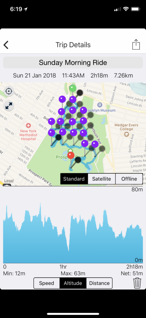
The walk followed grid-points spaced at 200m. The data collection process is detailed in the post “Field Data Collection (001): Prospect Park Walk“. The path was recorded using a Bad Elf GPS data logger and processed in QGIS, from which it was exported to GEOJSON. The altitude graph was built using d3.js, while the map-based representations used Mapbox GL.
Next Steps:
- Adjust zoom levels such that each visible extent is the same, and try another in which they are distinctly different.
- Smooth out the path by culling points recorded when we were stationary.
- Remove panning from aerial representation, or add interaction which snaps to the closest point on the path.
- Adjust x-axis of altitude graph to reflect time more accurately.
- Add hover interaction to plan representation.